VnExpress
Ho Chi Minh City to bury part of riverside road for underground mall in $1.1B overhaul
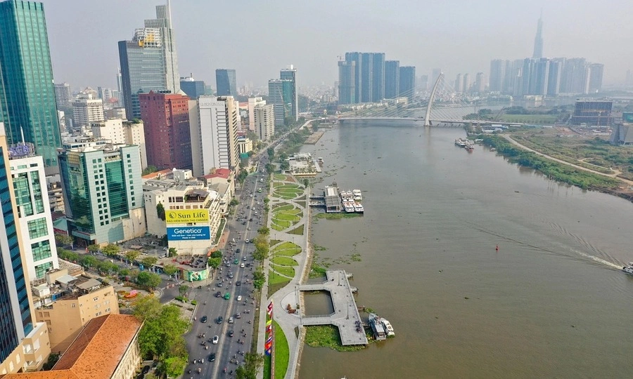
Ho Chi Minh City has proposed a nearly VND29.32 trillion (US$1.11 billion) makeover of its central Saigon River waterfront, including the historic wharf where President Ho Chi Minh set sail in 1911.
The plan, which the Ho Chi Minh City People's Committee has submitted to the municipal People's Council for review, would turn roughly 73.3 hectares of land and water surface along the river into a continuous corridor of parks, cultural venues, and public space running through the heart of the city.
It would be built under a public-private partnership using a build-transfer contract, in which the developer fronts the cost and is repaid by the city. Ben Nha Rong Tourism Services Co., Ltd. has come forward as the proposed investor.
The most striking change would come at Bach Dang Wharf in the central Saigon Ward (formerly District 1), where a section of Ton Duc Thang Street would be routed underground to clear the riverbank.
Beneath it, the city would build an underground car park and shopping center. Above ground, it would widen the embankment, add greenery, and upgrade the boat landings that serve the city's river buses and tourist cruises.
Across the water, the Nha Rong-Khanh Hoi zone would become a riverside cultural park. The headquarters of Saigon Port, one of the country's oldest, would be converted into offices, exhibition halls, and an events venue.
At the center of that zone sits a site of unusual weight in Vietnamese history. It was from this wharf, then known as Nha Rong, that 21-year-old Nguyen Tat Thanh boarded the French steamship Amiral Latouche-Tréville in 1911, working as a galley hand, and left Vietnam to search for a way to end French colonial rule. He returned three decades later as Ho Chi Minh, the revolutionary leader after whom the city was renamed in 1976.
The project would erect a full-scale model of the ship and expand the Ho Chi Minh Museum that already stands at the wharf, alongside new cultural, sports, and art facilities.
The heritage site and the Ho Chi Minh City branch of the Ho Chi Minh Museum at the Nha Rong-Khanh Hoi port. Photo by VnExpress/Quynh Tran
The riverfront push reflects a broader shift in a city long faulted as one of Asia's most park-starved. Ho Chi Minh City offers only about 0.7 sq.m of public park space per resident, far below the 8 to 10 sq.m its own planners treat as a livable baseline.
That is well under what Bangkok, Tokyo, and Seoul provide, according to comparative studies of urban green space. After decades of handing prime downtown land to high-rises, the city has begun setting aside some of its most valuable riverside plots for public use.
The plan also bundles in road projects to ease the chronic congestion between downtown and the southern districts. Nguyen Tat Thanh Street would be widened to eight to 10 lanes, with an underpass at the Hoang Dieu intersection.
A new Tan Thuan 1 Bridge would be built with six lanes and the neighboring Tan Thuan 2 Bridge widened to eight. A pedestrian bridge across the Saigon River has also been proposed to link the two riverfront zones.
The preliminary total investment covers construction, site clearance, and loan interest. Under the build-transfer terms, the developer would raise the money and be repaid with a mix of land and cash, about VND19.095 trillion in land and VND10.222 trillion from the city budget.
If the proposal is approved and an investor selected, construction would run from the third quarter of 2026 to the second quarter of 2029.
The strip from Ba Son Bridge to Tan Thuan Bridge, taking in Bach Dang Wharf and Nha Rong-Khanh Hoi, is widely regarded as the "frontage" of central Ho Chi Minh City.
The city is already building a separate pedestrian bridge linking Bach Dang Wharf to the new Thu Thiem urban area across the river, part of a wider campaign to turn its long-neglected riverbanks into the centerpiece of downtown.
View original source — VnExpress ↗
Related stories

Japan Times
NewsJun 18, 2026 · 1 min
Thailand revives $30 billion coast-to-coast corridor to rival Malacca Strait
Japan Times
The Guardian
TechnologyJun 17, 2026 · 1 min
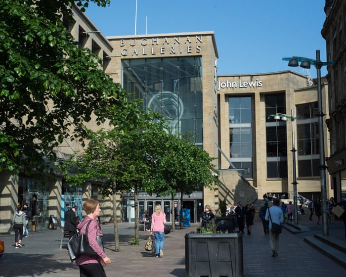
John Lewis injects £20m into Glasgow city centre store in wider branch reboot
The Guardian
Indian Express
TechnologyJun 17, 2026 · 1 min
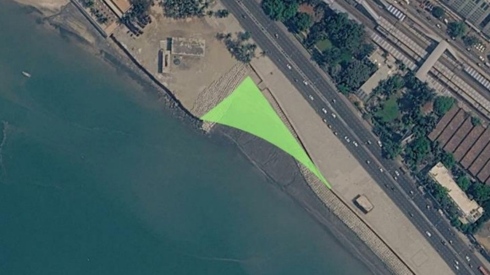
Marine Drive set for fresh reclamation as MMRDA plans road widening for Orange Gate tunnel
Indian Express

Rio Times
BusinessJun 18, 2026 · 1 min
South Africa Lands a $1 Billion BRICS Bank Loan to Fix Its Cities
Rio Times