Philippine Daily Inquirer
Rainy Wednesday in parts of Luzon, Visayas as typhoon moves away
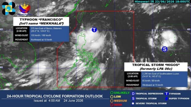
(Image from Pagasa / Facebook)
MANILA, Philippines — It will be a rainy Wednesday in parts of Luzon and the Visayas due to the southwest monsoon or “habagat” that is being enhanced by Typhoon Francisco (international name: Mekkhala) which is moving away from the country, the state weather bureau said.
“The rains we are currently experiencing in Metro Manila and nearby areas are being caused by the southwest monsoon,” Philippine Atmospheric, Geophysical and Astronomical Services Administration (Pagasa) weather specialist Chenel Dominguez said in Filipino.
Article continues after this advertisement
Pagasa said scattered rains and thunderstorms are expected in Metro Manila, Calabarzon (Cavite, Laguna, Batangas, Rizal, Quezon), Mimaropa (Mindoro, Marinduque, Romblon, Palawan) , the Bicol region, Western Visayas, and the Negros Island Region due to the “habagat.”
FEATURED STORIES
NEWSINFO
NEWSINFO
NEWSINFO
Typhoon’s track
Pagasa, in its early morning bulletin, reported that Typhoon Francisco was last located some 275 kilometers east of Basco, Batanes, packing a maximum sustained wind speed of 155 kilometers per hour (kph) with gusts of up to 190 kph while moving north at 10 kph.
Tropical Cyclone Wind Signal No. 1 is up over Batanes and the northeastern portion of Cagayan, including the Babuyan Islands, where strong winds and rains may still be experienced.
Dominguez said Francisco is forecast to remain in the typhoon category while inside the Philippine area of responsibility before gradually weakening to a severe tropical storm once it exits PAR.
Article continues after this advertisement
Storm outside PAR
Meanwhile, Pagasa is also monitoring another tropical storm with international name Higos outside the PAR.
Article continues after this advertisement
As of Wednesday morning, Higos was spotted some 2,285 kilometers east of southeastern Luzon, carrying maximum sustained winds of 65 kph and gusts of up to 80 kph while moving west at 15 kph.
The weather disturbance is expected to enter PAR on Thursday and will be assigned the local name “Gardo.”
Dominguez, however, said the tropical storm is forecast to remain far from the Philippine landmass and is not expected to directly affect the country even as it enters PAR.
Your subscription could not be saved. Please try again.
Your subscription has been successful.
“It remains far from our landmass and is only near the edge of the Philippine area of responsibility, so we do not expect it to have any significant effect on rainfall or winds in the country,” Dominguez explained. /gsg
View original source — Philippine Daily Inquirer ↗
Related stories

The Guardian
TechnologyJun 24, 2026 · 1 min
Ukraine war briefing: Crimea locks down as Putin acknowledges ‘huge stream’ of Ukrainian drones
The Guardian

TechRadar
TechnologyJun 24, 2026 · 1 min
MSI's 'super-light, hyper-functional' portable monitor drops 32% for Prime Day
TechRadar

South China Morning Post
TechnologyJun 24, 2026 · 1 min
As China plans for demographic crisis, some sectors see opportunity
South China Morning Post

TechRadar
TechnologyJun 24, 2026 · 1 min
The best Amazon Prime Day TV deals this year
TechRadar