VnExpress
Storm Maysak approaches Ha Long Bay, heavy rains expected from Saturday afternoon
Storm Maysak is forecast to directly impact the coastal areas of Quang Ninh and Hai Phong from midday Saturday, bringing sustained winds of 62–88 kph and severe torrential rain to northeastern Vietnam.
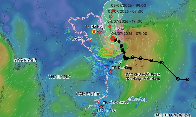
According to the National Center for Hydro-Meteorological Forecasting, Maysak lay centered approximately 55 km southeast of Bach Long Vi Island off Hai Phong City and 160 km southeast of Mong Cai in Quang Ninh Province as of 8:00 a.m. Saturday.
The storm is moving northwest at 15 kph, packing maximum sustained winds of 88 kph, with gusts reaching up to 117 kph. By 4:00 p.m. on Saturday, the center is expected to reach the waters off Quang Ninh, home to Ha Long Bay. The wind speed is anticipated to remain steady.
Following this, the storm is forecast to turn north, traveling at 10–15 kph before making landfall in southern Guangxi, China, late Saturday or early Sunday. It will likely weaken into a tropical depression and eventually dissipate.
A predicted trajectory of Storm Maysak in the East Sea. Graphic by Vietnam Disaster Monitoring System
International monitors note a similar path. The Japan Meteorological Agency reports current sustained winds of 72 kph, while the Hong Kong Observatory anticipates the storm will maintain winds of about 85 kph as it brushes past Mong Cai. Both expect the storm to retain its strength until reaching the border area.
The storm's trajectory has notably shifted since Friday's forecasts. Instead of moving west-northwest at a slower pace of 7 kph, Maysak has accelerated to 15–20 kph, tracking north-northwest into the northern Gulf of Tonkin.
Expected impacts
Across the Gulf of Tonkin, including Bach Long Vi, Van Don, Co To, Cat Hai, and Hon Dau Island, strong winds of 39–61 kph are expected Saturday. Areas nearer the storm's center will face even stronger gusts.
With waves forecast at 2–4 m, these hazardous sea conditions pose a severe threat to fishing vessels, cargo ships, and tourist boats. Maritime transport, aquaculture, and coastal infrastructure may face significant disruptions.
Coastal regions of Quang Ninh, Hai Phong, and Hung Yen will experience winds of 39–49 kph, strengthening to 74 kph near the eye of the storm.
Waves of 2–3 meters, combined with a storm surge of 0.2–0.4 meters, threaten to cause flooding at river mouths and low-lying coastal areas. Sea dikes, embankments, and transport networks are also at risk.
The storm's circulation will bring heavy downpours to northeastern Vietnam, including Lang Son, Quang Ninh, Hai Phong, Bac Ninh, and Thanh Hoa, continuing through Sunday.
Most areas will see 100–200 mm of rain. However, the broader northeast region may receive 200–300 mm, with some locations facing 500 mm.
These downpours present a high risk of urban flooding, inundation of industrial parks, and severe flash floods and landslides in mountainous regions. Meteorologists warn that the storm's outer bands could spawn thunderstorms, tornadoes, and damaging wind gusts before and during landfall. Residents are urged to monitor the situation closely.
The National Civil Defense Steering Committee and the Ministry of Agriculture and Environment have issued an emergency directive in response to the approaching storm.
Northeastern provinces and Thanh Hoa have been ordered to account for all vessels and identify areas at high risk for flooding and landslides to prepare for potential evacuations.
As of Thursday, authorities had successfully directed more than 56,200 vessels carrying nearly 250,000 people to safe shelter. In response to the escalating threat, Quang Ninh, Hai Phong, and Ninh Binh have imposed sea bans from Friday.
View original source — VnExpress ↗
Related stories

Philippine Daily Inquirer
WorldJul 4, 2026 · 1 min
LOOK: Bomb threat disrupts operations at mall in Cebu IT Park
Philippine Daily Inquirer

RNZ
WorldJul 4, 2026 · 1 min
Smell of smoke in Air NZ plane cabin triggers emergency reponse at Christchurch Airport
RNZ

Euronews
WorldJul 4, 2026 · 1 min
A Silk Road destination wants tourists to stay longer
Euronews

South China Morning Post
WorldJul 4, 2026 · 1 min
‘Cherry-picked’ crimes: call for legal reforms to cover long-term child sexual abuse
South China Morning Post