CNA
Nature groups call for stronger environmental safeguards over Sunset Way, Gillman Barracks housing plans
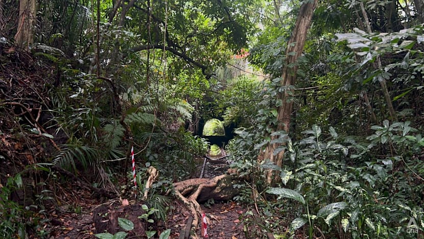
SINGAPORE: More than three decades after the old Jurong railway ceased operations, its tracks have given way to Maju Forest, a regenerating secondary forest nestled between Clementi Forest and the Rail Corridor.
“If you look around, you see tree ferns and all, and just above us is the busy Clementi Road. Just a step off, and you are immersed into a magical world,” said Mr Leong Kwok Peng, president of the Nature Society Singapore (NSS).
But that landscape may soon change, with plans to clear about 15ha of the forest – the size of about 21 football fields – to make way for a new residential estate.
The Housing and Development Board (HDB) announced on Friday (Jul 10) that Sunset Way, along with Gillman Barracks, will be developed for housing. It follows the completion of environmental and heritage studies commissioned to better understand the sites' ecology and guide redevelopment plans.
While mitigation measures have been planned to reduce environmental impacts, some nature groups say the developments will still result in the loss of valuable green spaces and are calling for stronger environmental safeguards.
SUNSET WAY
The Sunset Way site sits within the existing Maju Forest and has been largely zoned for residential use since the Master Plan 1980.
It comprises five habitat types, including 4.7ha of native-dominated secondary forest, almost 10ha of abandoned land forest, and three natural streams.
The study recorded several native and conservation-significant species, including the critically endangered straw-headed bulbul.
After mitigation measures, the environmental study found the project could have "major negative to no significant" impacts on biodiversity during the pre-construction and construction phases.
Based on findings, HDB will retain about 8ha of the 23ha study area, including a freshwater stream and its surrounding riparian buffer, to provide refuge for wildlife and facilitate fauna movement.
Mr Leong said large patches of secondary forests like Maju Forest are “very few and far between”.
“Once it's cleared, it's irreversible. You can't replace it. It takes decades for secondary forest to grow,” he said, adding that secondary forests also contribute to the ecosystem by cooling the air and retaining rainfall.
HDB has proposed retaining a forest stream and most of the native-dominated secondary forest, which makes up about a quarter of the study area.
Mr Leong said that with a smaller forested area, animals might be forced out, increasing the likelihood of roadkill.
Mr Ho Xiang Tian, co-founder of LepakInSG, said the presence of nutmeg found deep within Maju Forest suggests it remains well connected to nature reserves.
“Keeping it allows animals to move from Bukit Timah Nature Reserve down to Southern Ridges and have habitats in between to stay at rather than be forced to keep moving,” he said.
After the development, the remaining forest will function less as a habitat and more as an ecological connectivity corridor, he said.
As part of mitigation measures, a directional clearance plan will allow animals to move to adjacent greenery.
Mr Ho said that LepakInSG, which was among the nature groups consulted, has raised that shepherding wildlife only means they will not be killed during development.
“But they would need to compete for space and resources with whatever animals are already in the place they are being shepherded to, so something is still going to die or get displaced by this development,” he added.
GILLMAN BARRACKS
At Gillman Barracks, the study area includes 21.8ha of forest – about the size of 30 football fields – and 10ha of urban vegetation and scrubland/grassland.
CNA understands that at least 10ha of forest could be cleared for the upcoming developments.
According to the study, the development could have "no change to major negative" impacts on habitats and food sources for fauna during the construction phase, even after mitigation measures.
Mr Lester Tan, chairperson of the Marine Conservation Group at NSS, said that if the environmental monitoring and management plan is carried out properly, most of the trees will not be affected.
“However, there will be some connectivity issues because we are still clearing a huge portion of the forest.
“We are now limiting them to a small corridor … between the upper parts of the Southern Ridges all the way to the lower parts of the Southern Ridges,” he said.
To maintain ecological connectivity and minimise impact on biodiversity, HDB said agencies will safeguard ecological corridors with a minimum width of 30m.
These corridors connect Telok Blangah Hill Park to HortPark in the west and to Berlayar Creek and Labrador Nature Reserve in the south, and will keep the site linked to the broader Southern Ridges ecological network.
Mr Tan said it is “great news” that the authorities are keeping the native-dominated forest and maintaining a slim corridor from the north to south of Gillman Barracks to Berlayar Creek.
He added that the proposed retained freshwater stream is also important because it provides diverse habitats and allows different flora and fauna to thrive.
“So, all these measures being proposed are great for this area. We're not losing the area in total, however, more could be done in terms of widening the connectivity if space were given,” he said.
OPEN TO PUBLIC FEEDBACK
The full reports for Gillman Barracks and Sunset Way have been published on the HDB InfoWeb. Members of the public can share their feedback from Jul 10 to Aug 6.
HDB said the findings of the environmental studies and public feedback will inform the development plans for the sites, including the eventual housing yield, housing mix, flat classification, and development timeline.
In response to queries from CNA, HDB said it has engaged various stakeholders, such as nature groups and has incorporated their suggestions where feasible. NSS was among the nature groups consulted.
“Following the publishing of the study reports, members of the public can share their feedback for agencies to consider in the development plans for both sites,” the agency said.
HDB added that the final list of mitigation measures for both sites will be decided after agencies have reviewed all public feedback, and where appropriate, additional measures or monitoring requirements may be incorporated.
The finalised mitigation measures will also inform the environmental management and monitoring plan.
The National Parks Board (NParks) said that it will review the plan prior to the commencement of works.
It will coordinate with relevant agencies and consultants to ensure the mitigation efforts are cohesive and sufficiently address potential impacts from the respective projects, NParks added.
Related stories

Straits Times
WorldJul 10, 2026 · 1 min
How the absence of Iran's new supreme leader is becoming a liability for the Islamic Republic
Straits Times

Euronews
WorldJul 10, 2026 · 1 min
Music bans and fines for peeing: Europe’s surprising beach rules travellers should know this summer
Euronews

Indian Express
WorldJul 10, 2026 · 1 min
Bengaluru police arrest 4 for kidnapping, robbing self-styled spiritual healer
Indian Express

Portugal Resident
WorldJul 10, 2026 · 1 min
News Review: Bonnie Tyler tributes, earthquake warning & burqa ban
Portugal Resident