Philippine Daily Inquirer
LPA outside PAR likely to become tropical depression within 24 hours
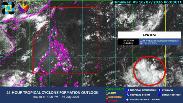
MANILA, Philippines — A low-pressure area (LPA) being monitored outside the Philippine area of responsibility (PAR) has a high chance of developing into a tropical depression within 24 hours, the state weather bureau said Thursday.
READ: Pagasa: Fair weather, isolated rains forecast over PH
In a tropical cyclone formation outlook issued at 4 p.m., the Philippine Atmospheric, Geophysical, and Astronomical Services Administration (Pagasa) said the LPA was located 2,915 kilometers east of Southeastern Mindanao as of 2 p.m.
Article continues after this advertisement
“As of 2:00 p.m. today, July 16, 2026, a Low Pressure Area (LPA 07c) is being monitored outside the Philippine Area of Responsibility (PAR) and has a high chance of developing into a tropical depression within the next 24 hours,” Pagasa said.
FEATURED STORIES
NEWSINFO
NEWSINFO
NEWSINFO
READ: Angat Dam’s water level still below critical threshold – Pagasa
Meanwhile, in the 5 a.m. weather forecast, Pagasa weather specialist Leanne Loreto said no weather disturbances are expected to develop inside the PAR within the next four to five days.
However, she said the southwest monsoon is expected to intensify and affect the western sections of Northern and Central Luzon by the weekend. /mcm
Your subscription could not be saved. Please try again.
Your subscription has been successful.
View original source — Philippine Daily Inquirer ↗
Related stories

The Punch
WorldJul 16, 2026 · 1 min
CAC to deregister 100,000 companies over unfiled returns
The Punch
The Punch
WorldJul 16, 2026 · 1 min
Man gets seven-year jail term for advertising cannabis online
The Punch
The Punch
WorldJul 16, 2026 · 1 min
FG unveils initiative to unlock DNA research, boost healthcare
The Punch
The Punch
WorldJul 16, 2026 · 1 min
I’m not afraid to return to school, rescued Oyo pupil recounts ordeal in bandits’ captivity
The Punch