Philippine Daily Inquirer
Philippine Daily Inquirer··1 min read
LPA outside PAR has even chance to be tropical depression
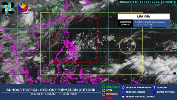
MANILA, Philippines — A low pressure area (LPA) outside the Philippine area of responsibility (PAR) has an even chance of developing into a tropical depression within the next 24 hours, the state weather bureau said.
In its early morning bulletin, the Philippine Atmospheric, Geophysical and Astronomical Services Administration (Pagasa) said the LPA was located around 2,430 kilometers east of Eastern Visayas and could intensify into a tropical cyclone while still outside PAR.
Article continues after this advertisement
“As of now, it is not directly affecting any part of the Philippines,” Pagasa weather specialist Leanne Loreto said.
FEATURED STORIES
NEWSINFO
NEWSINFO
NEWSINFO
If the weather disturbance develops into a tropical cyclone and enters PAR over the weekend, it will be given the local name “Francisco.”
“It is less likely that the system will make landfall in any part of the country,” Loreto added.
Pagasa, however, said it could then enhance the southwest monsoon or “habagat” by Sunday or Monday.
Easterlies prevail
Article continues after this advertisement
Meanwhile, partly cloudy to cloudy skies with isolated rain showers or thunderstorms due to the easterlies are expected in Southern Luzon, the Visayas, and the eastern section of Mindanao.
“We expect hot and humid conditions to prevail across large parts of the country… although isolated rainshowers remain possible,” said Loreto.
Article continues after this advertisement
Metro Manila and the rest of the country may also experience partly cloudy to cloudy skies with isolated rain showers or thunderstorms, mostly due to localized thunderstorms.
“Even during the rainy season, we can still experience hot weather because of the monsoon break,” explained Loreto.
Your subscription could not be saved. Please try again.
Your subscription has been successful.
No gale warning is inn effect, while coastal waters across the country expected to remain slight to moderate. /gsg
View original source — Philippine Daily Inquirer ↗
Related stories

Philippine Daily Inquirer
NewsJun 17, 2026 · 1 min
LPA outside PAR has ‘medium’ chance of turning into tropical depression
Philippine Daily Inquirer

South China Morning Post
NewsJun 4, 2026 · 1 min
Hong Kong braces for heat, showers as tropical depression passes nearby
South China Morning Post
VnExpress
NewsJun 4, 2026 · 1 min
Vietnam sees first tropical depression of 2026 form in East Sea
VnExpress

Mexico News Daily
TechnologyJun 18, 2026 · 1 min
As a storm system forms in the Gulf, rain pummels Mexico’s north and east
Mexico News Daily