
Antara News
Antara News··2 min read
Indonesia maps liquefaction-prone zones in quake-hit Central Sulawesi
..the newly released data and hazard distribution maps would serve as a key reference for local governments in formulating spatial planning and safe-zone policies.
Jakarta (ANTARA) - Indonesia’s geological agency has mapped several areas in Central Sulawesi province that face a high vulnerability to liquefaction following a 6.7-magnitude earthquake that struck the region days ago.
Speaking in Jakarta on Friday, Lana Saria, the head of the Geological Agency at the Ministry of Energy and Mineral Resources, announced that an updated technical monitoring map highlights four regencies and cities requiring intensive attention.
The areas identified are Sigi Regency, Palu City, Parigi Moutong Regency, and parts of Poso Regency. Saria explained that liquefaction potentially occurs in water-saturated sandy soil layers when subjected to strong seismic shaking.
The agency clarified that the designated status does not mean liquefaction will instantly occur across all identified points. Rather, it serves as a scientific indicator signaling the need for heightened vigilance and reinforced structural mitigation.
According to geological theory, an onshore earthquake can increase pore water pressure in saturated sandy soils.
This process reduces the soil's load-bearing capacity, causing the ground to lose its strength and stability.
As a result, the agency said more detailed microzonation studies are needed to determine site-specific risk classifications for each location within the four regions.
Saria expressed hope that the newly released data and hazard distribution maps would serve as a key reference for local governments in formulating spatial planning and safe-zone policies.
The agency also identified areas with high earthquake vulnerability, including several sub-districts in Sigi Regency and Palu City, such as Dolo, Gumbasa, Marawola, Tanambulava, West Palu, South Palu, and North Palu.
Other surrounding areas fall into medium-to-high risk categories.
The vulnerability map was compiled using various geological parameters, including active faults, soil and rock characteristics, seismic history, and the potential intensity of ground shaking.
"The vulnerability map is not a prediction of when an earthquake will occur, but rather an overview of potential hazard levels if a quake strikes the area," Saria said.
She urged local disaster management authorities and residents to remain calm but vigilant, stressing that geological resilience must be a key consideration in post-disaster infrastructure and housing reconstruction.
Related news: BMKG records 782 aftershocks as Sulawesi quake death toll hits three
Related news: Central Sulawesi declares earthquake emergency response for one week
Translator: M. Riezko Bima Elko Prasetyo, Aditya Eko Sigit Wic
Editor: M Razi Rahman
Copyright © ANTARA 2026
View original source — Antara News ↗
Related stories

Philippine Daily Inquirer
NewsJun 10, 2026 · 1 min
Capitol maps out plans for ‘The Big One’ in Cebu
Philippine Daily Inquirer

Philippine Daily Inquirer
NewsJun 9, 2026 · 1 min
Pangasinan to extend financial aid to Mindanao quake-hit provinces
Philippine Daily Inquirer
The Guardian
TechnologyJun 9, 2026 · 1 min
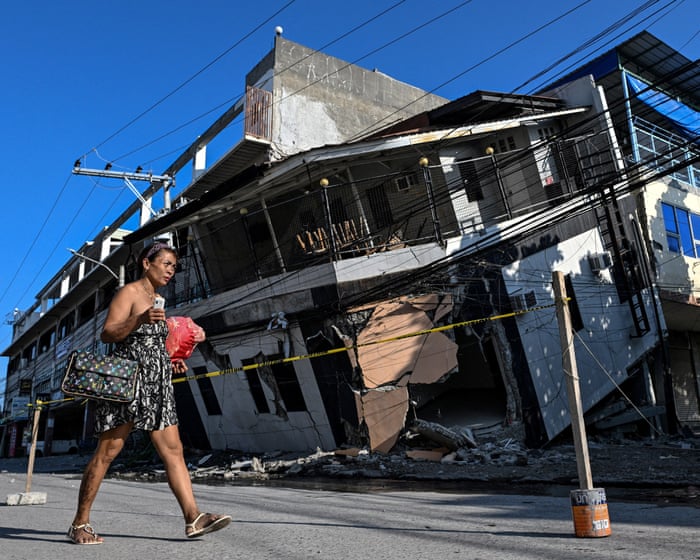
Buildings destroyed after 7.8 magnitude earthquake in Philippines – video
The Guardian
South China Morning Post
NewsJun 8, 2026 · 1 min
Mindanao quake exposes Philippines’ vulnerability to ‘Big One’ tremor in Metro Manila
South China Morning Post