
Philippine Daily Inquirer
Philippine Daily Inquirer··1 min read
Trough of tropical storm to bring rains to Visayas, Mindanao
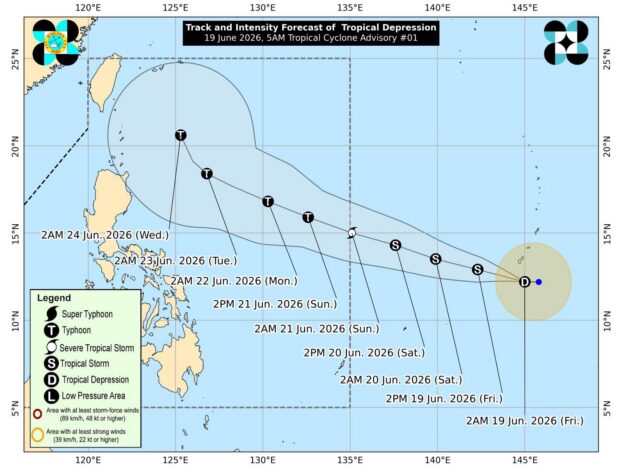
MANILA – The trough of a tropical storm outside the Philippine Area of Responsibility (PAR) is forecast to bring rains to several parts of the Visayas and Mindanao, the weather bureau said Saturday.
As of 3 a.m., Tropical Storm Mekkhala was spotted 1,665 km. east of Southeastern Luzon, packing maximum sustained winds of 75 kph near the center with gustiness of up to 90 kph, and moving west-northwestward at 25 kph.
The Philippine Atmospheric, Geophysical and Astronomical Services Administration (PAGASA) forecast the tropical storm to enter the PAR between late Saturday afternoon and Sunday morning and will be named Francisco.
READ: Easterlies to drench parts of Luzon, Visayas as TD hovers outside PAR
A landfall scenario is less likely at this time, but it will continue to intensify and may reach typhoon category by Sunday.
However, the cyclone is less likely to directly affect the weather and sea conditions in the country in the next two days, PAGASA said.
The cyclone’s trough will bring cloudy skies with scattered rains and thunderstorms over Eastern Samar, Southern Leyte, Dinagat Islands, and Surigao del Norte.
READ: Cebu City readies ₱30M fund, expands farmer assistance as El Niño looms
Flash floods or landslides may occur during moderate to at times heavy rains, PAGASA warned.
The rest of the country will experience partly cloudy to cloudy skies with isolated rainshowers or thunderstorms due to the easterlies and localized thunderstorms.
Light to moderate winds and slight to moderate seas will prevail across the archipelago. (PNA)
Your subscription could not be saved. Please try again.
Your subscription has been successful.
Read Next
Disclaimer: The comments uploaded on this site do not necessarily represent or reflect the views of management and owner of Cebudailynews. We reserve the right to exclude comments that we deem to be inconsistent with our editorial standards.
View original source — Philippine Daily Inquirer ↗
Related stories

Philippine Daily Inquirer
NewsJun 19, 2026 · 1 min
Cyclone outside PAR now tropical storm; rains seen in parts of PH
Philippine Daily Inquirer

Philippine Daily Inquirer
NewsJun 19, 2026 · 1 min
Tropical depression outside PAR may become a storm late Friday
Philippine Daily Inquirer
Philippine Daily Inquirer
NewsJun 18, 2026 · 1 min
Tropical depression east of Visayas may enter PAR by weekend
Philippine Daily Inquirer

Mexico News Daily
TechnologyJun 18, 2026 · 1 min
As a storm system forms in the Gulf, rain pummels Mexico’s north and east
Mexico News Daily