Philippine Daily Inquirer
Philippine Daily Inquirer··1 min read
Tropical depression east of Visayas may enter PAR by weekend
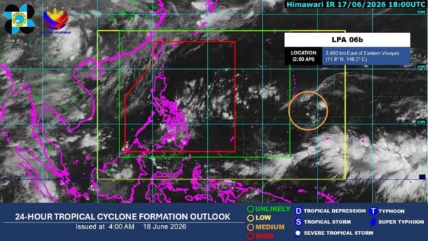
MANILA, Philippines — A tropical depression east of Visayas may enter the Philippine area of responsibility (PAR) by Saturday night, according to the state weather bureau.
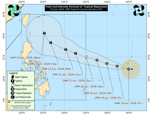
The Philippine Atmospheric, Geophysical and Astronomical Services Administration (Pagasa) on Friday morning said that the tropical depression was spotted some 2,085 kilometers east of Eastern Visayas.
It is packing a maximum sustained wind speed of 55 kilometers per hour (kph) near the center and gustiness of up to 70 kph while moving west at 15 kph.
Article continues after this advertisement
“It is not yet affecting the country, but we are monitoring it as it is expected to enter the Philippine area of responsibility, possibly by late Saturday night or early Sunday morning,” Pagasa weather specialist Obet Badrina said.
FEATURED STORIES
NEWSINFO
NEWSINFO
NEWSINFO
The tropical depression, Pagasa said, is expected to steadily intensify and may reach typhoon category by Sunday evening while moving northwest over the Philippine Sea.
It will be named Francisco once it enters PAR.
The weather bureau, however, said the cyclone remains less likely to make landfall over the country.
‘Habagat’ trigger
Article continues after this advertisement
While the tropical depression is not expected to directly affect the country’s weather in the next three days, Pagasa said it could trigger the southwest monsoon or “habagat” and enhance rainfall in parts of Visayas and Southern Luzon early next week.
Meanwhile, fair, warm weather due to the easterlies is expected in Metro Manila, Visayas, Central Luzon, Calabarzon (Cavite, Laguna, Batangas, Rizal, Queon), Mimaropa (Mindoro, Marinduque, Romblon, Palawan) and the Bicol region.
Article continues after this advertisement
Isolated rain showers and thunderstorms are possible, particularly in the afternoon and evening. /gsg
Your subscription could not be saved. Please try again.
Your subscription has been successful.
View original source — Philippine Daily Inquirer ↗
Related stories
Philippine Daily Inquirer
NewsJun 17, 2026 · 1 min
LPA outside PAR has even chance to be tropical depression
Philippine Daily Inquirer

Philippine Daily Inquirer
NewsJun 17, 2026 · 1 min
LPA outside PAR has ‘medium’ chance of turning into tropical depression
Philippine Daily Inquirer

Philippine Daily Inquirer
NewsJun 19, 2026 · 1 min
Cyclone likely to enter PAR on Saturday, may trigger 'habagat'
Philippine Daily Inquirer

South China Morning Post
NewsJun 4, 2026 · 1 min
Hong Kong braces for heat, showers as tropical depression passes nearby
South China Morning Post